
| DATE: | March 28, 1997 | WEATHER: | very hot, clear, windy, slight showers | HIKERS: | Daryn Ohta, Grant Tokumi, David Koseki |
| Pictures by Daryn, David, and Grant |
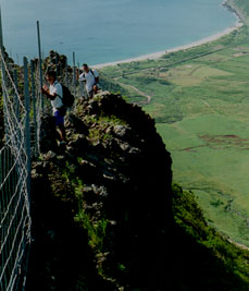
 Around a quarter way into the hike, we met up with this irritating steel
fence. We assumed the purpose of the fence was to keep goats out of the
inner parts of the valley. The fence followed the trail all the way to
just about the very end of the hike. It had its good and bad points. It
was most disappointing because the site of this ugly fence really
distracted us from much of the natural beauty on the hike. It was also
bad because it sat right in the middle of the already narrow ridge, so we
were forced to be even closer to the edge than we needed to be, and had
to climb over the fence numerous times when the opposing side presented a
better walking surface. The good point was that the fence always gave
something to hold on to when needed. Some parts of the ridge was very
narrow, and the ground was also very crumbly, so the fence gave a sense of
security when crossing those dangerous areas.
Around a quarter way into the hike, we met up with this irritating steel
fence. We assumed the purpose of the fence was to keep goats out of the
inner parts of the valley. The fence followed the trail all the way to
just about the very end of the hike. It had its good and bad points. It
was most disappointing because the site of this ugly fence really
distracted us from much of the natural beauty on the hike. It was also
bad because it sat right in the middle of the already narrow ridge, so we
were forced to be even closer to the edge than we needed to be, and had
to climb over the fence numerous times when the opposing side presented a
better walking surface. The good point was that the fence always gave
something to hold on to when needed. Some parts of the ridge was very
narrow, and the ground was also very crumbly, so the fence gave a sense of
security when crossing those dangerous areas.
 Grant and Daryn taking a short break after some steep climbing at the beginning portion of the hike.
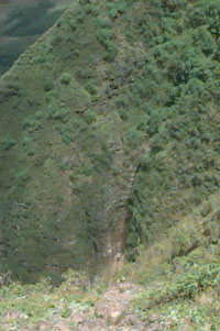 We found this nice dried up waterfall carved into the mountain in one of
the mini valleys. It would have looked very nice if it was flowing.
We found this nice dried up waterfall carved into the mountain in one of
the mini valleys. It would have looked very nice if it was flowing.
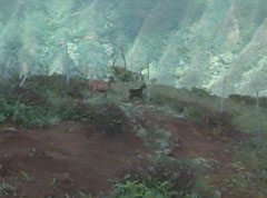 We spotted goats numerous times, and for most of the hike, we could hear
the goats and birds laughing at us because we couldn't walk (or fly) as
fast as they could. They usually kept their safe distance from us, but at
one area, the fence prevented them from running away and allowed us to
get closer to take this picture of them. It looks like a mother goat
(brown) and her little baby goat (black).
We spotted goats numerous times, and for most of the hike, we could hear
the goats and birds laughing at us because we couldn't walk (or fly) as
fast as they could. They usually kept their safe distance from us, but at
one area, the fence prevented them from running away and allowed us to
get closer to take this picture of them. It looks like a mother goat
(brown) and her little baby goat (black).
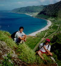
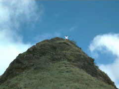 (LEFT) - Daryn celebrating our 4.5 hour trek to the summit.
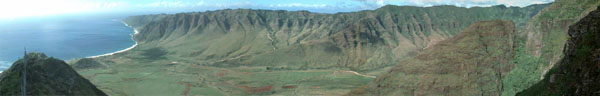
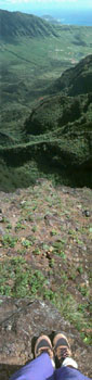
(RIGHT) - An out of perspective vertical panoramic shot made from 3
pictures. I'm actually standing on the edge of a fairly steep drop. The
bottom picture is looking straight down at my feet, the top picture is
looking straight out towards the Makaha and Waianae area.
 That mountain is Mt. Ka`ala, the highest peak on Oahu.
 Group shot from the summit before our return trip. From left to right:
Grant, Daryn, and David.
Group shot from the summit before our return trip. From left to right:
Grant, Daryn, and David.
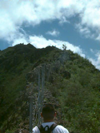
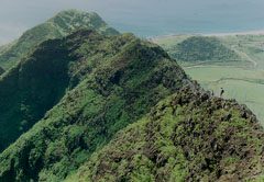 Hiking along the narrow ridge with assistance from the fence.
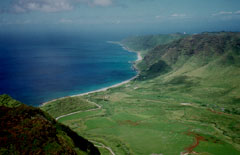 Another nice view of the Waianae coastline.
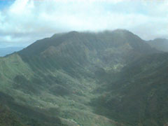
 A nice shot of Ohikilolo in the late afternoon sun. We were a little worried that we may be hiking in the dark (with no flashlights), but we made it out just in time before the sun went down.
The hike took 8.5 to 9 hours to complete. Its very hot so take plenty and plenty and plenty of water. There were some scary areas, but it wasn't as bad or dangerous as I was expecting this hike to be. The rocks were very crumbly so don't trust any rock, even the bigger ones when climbing up walls. Its a very long hike, but the views at the summit is spectacular and well worth the effort to get there.

Custom Search
|